Must-See Stops: Oro Grande to Amboy, California
Long before the interstates erased most of the drama, the National Old Trails Highway carried travelers across the Mojave from New Mexico into California. Later aligned as Route 66, this stretch still exists as County Route 66 and the signed National Trails Highway. Today only scattered buildings, folk-art oddities, and weathered service stations remain, yet the road delivers one of the purest surviving pieces of the Mother Road in California.
This drive begins near Victorville and runs east through Oro Grande, Helendale, Barstow, Daggett, Newberry Springs, and on toward Amboy. Expect wide-open desert, limited services, and constant reminders that the interstate took the traffic decades ago. Fill the tank, carry water, and travel in daylight. The full Victorville-to-Needles distance is roughly 175 miles; the core section covered here is shorter but still rewards a full day of slow driving and short stops.

First Stop: Oro Grande’s Mining Roots and Roadside Gems
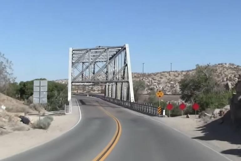
Leave Victorville heading east on the National Old Trails Highway. Almost immediately, the road crosses the Mojave River on a 1930s steel-truss bridge, then enters what remains of Oro Grande. Early prospectors hoped for gold; the real fortune turned out to be limestone. The CalPortland Cement Plant still dominates the skyline and keeps the town from vanishing completely.
Scattered along the highway, you will find the unused Mohawk Mini-Mart, the Antique Station (a large high-desert antique complex), and an old mining-era graveyard. A practical and popular stop is Cross Eyed Cow Pizza at 19242 National Trails Highway. Housed in a former 1920s Studebaker shop now styled as a red barn, it serves solid pizza, wings, and sandwiches in a quirky setting that fits the road’s character.

Elmer’s Bottle Tree Ranch: Glass and Steel in the Desert
Four miles farther east sits one of Route 66’s most photographed attractions. Elmer Long spent years welding junkyard steel into “trees” and covering them with colored bottles, signs, car parts, and found objects. The result is a wide outdoor folk-art installation at 24266 National Trails Highway, Oro Grande.
Elmer died in 2019. His son Elliott has kept the ranch open to the public free of charge (donations welcome). Arid wind, heat, and time take a constant toll, and maintenance is an ongoing struggle, yet the trees still catch the late-afternoon light in brilliant colors. Walk the paths, photograph the installations, and leave the place better than you found it.
Helendale and Silver Lakes: Fading Storefronts Beside a Desert Oasis
Continue east into the remains of Helendale. Only a handful of buildings survive among the sagebrush. Look for Burden’s Store and the U.S. Post Office, constructed in 1926 and among the oldest structures still standing on this section of the highway. Nearby stand the scattered remains of Potapov’s Service Station and Auto Court, dating to 1943.
Just off the old alignment lies Silver Lakes, a residential community built around two artificial lakes and a golf course. It offers a sharp contrast to the abandoned roadside buildings: modern housing, water recreation, and a sense of permanence the earliest highway towns never achieved.
Barstow: Rail Town Turned Route 66 Hub
East of Helendale, the road grows quieter until it reaches Barstow, one of the larger communities on this stretch. Named for a Santa Fe Railroad president, Barstow grew with the mining camps of Daggett and Calico in the late 1800s and became a major rail center. In 1926, Route 66 was routed straight through town on Main Street.
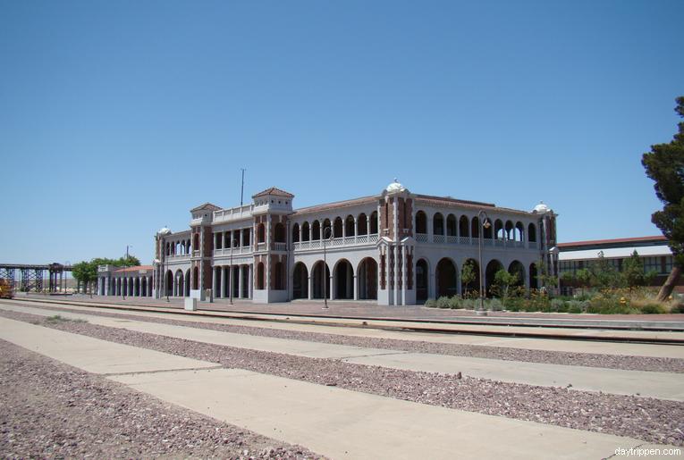
The prominent landmark is Casa del Desierto, the 1911 Harvey House railroad depot. Fully restored, it now houses the Route 66 Mother Road Museum and the Western America Railroad Museum. After a temporary closure caused by flood damage, the Route 66 museum reopened in 2025 and remains free to visit (check current hours, which are limited). The building also serves as an active Amtrak station. It is the best single stop in Barstow for learning about both the railroad and highway eras.
Daggett: Silver, Borax, and Surviving Structures
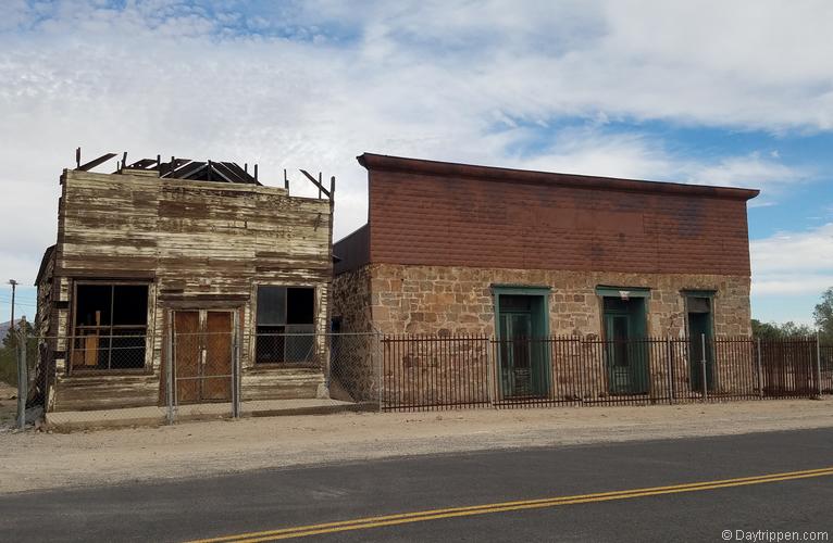
Twelve miles east of Barstow lies Daggett. Founded in the 1860s, the town boomed first on silver from the Calico Mountains and later on borax. A blacksmith shop and an old hotel still stand among the dusty lots, quiet evidence of a once-busy supply point for the mines.

Bagdad Cafe and the Empty Miles Beyond
Newberry Springs is next. The Bagdad Cafe, made famous by the 1987 film of the same name, is still a popular pilgrimage stop even though the kitchen has been closed for some time. Visitors can still buy snacks, drinks, and souvenirs inside a building covered with international flags, photos, and memorabilia. Longtime owner Andrea Pruett died in January 2026; family and supporters continue to keep the doors open as a roadside attraction. The Airstream trailers used in the movie still sit in the parking lot.
East of Newberry Springs, the highway grows emptier. Remnants of Fenner, Essex, and other once-busy stops appear and disappear—old post offices, gas-station foundations, and the occasional abandoned motel cabin.

Amboy and the Final Desert Stretch
The National Old Trails Highway continues through Ludlow and on to Amboy, home of the iconic Roy’s Motel & Cafe. The giant Googie-style illuminated sign still rises above the desert floor. The gas station and gift shop are open; the cafe and motel cottages remain closed but are targeted for restoration. Amboy Crater, a volcanic cinder cone just west of town, offers a short hike and sweeping views of the lava fields.
This entire corridor from Oro Grande to Amboy is the National Old Trails Highway at its most authentic: long straightaways, little traffic, and constant reminders of the businesses and people the interstate left behind.
Important Notes for the Drive
Services are sparse between Barstow and Needles. Fuel up in Barstow or at Roy’s in Amboy when available. Carry extra water and check the weather—summer temperatures regularly exceed 110°F. The road is paved but remote; cell service can be spotty. Daytime travel is strongly recommended.

Why Drive National Old Trails Highway
Driving the National Old Trails Highway from Oro Grande to Amboy is less about noting off attractions and more about sensing what Route 66 felt like before the freeways arrived. The bottle trees still sparkle, the old post offices still stand, and the desert still stretches uninterrupted to the horizon. In an age of six-lane interstates, this quieter alignment remains one of the best places left in California to feel the authentic spirit of the Mother Road. Take your time, stop often, and let the empty miles do the rest of the talking.
Grand Canyon Caverns, Arizona’s Route 66 Roadside Attraction
Discover more from Daytrippen.com
Subscribe to get the latest posts sent to your email.
Another point of interest is Cross Eyed Cow Pizza in Oro Grande California.
Elmer actually passed a couple of years ago, I haven’t been to Bottle Tree Ranch since his death, so I’m not sure if it’s being maintained. Hopefully, because it is a cool place!
The bottled ranch is open now; there is a Facebook page and website. Or you can do a drive-by.
It is maintained . Was just there.
Thanks for the update.
What about Silver lakes a beautiful resort between victorville and Barstow on route 66